Project Proposal
1. Motivation of Project
Land cover classification is an important remote sensing application. Accurate identification of land cover provides a proper baseline for activities like change detection and thematic mapping to make planning decisions.
Through supervised classification, we can understand the strengths and weaknesses of the 2 satellites.
2. Project Objective
The objective of the project is to study and compare the differences in remote sensing satellite data (Landsat 8, Sentinel-2). Through the project, we will also learn the pre-processing procedure and general flow of any land-cover classification. By analyzing different classification results with various machine learning algorithms, we can get a deep understanding of discriminating machine learning problems.
3. Data Collected
The study area is located at the north of Singapore. The north of Singapore holds a variety of landscape characteristics which is useful for classification.
4. Scope of Work
Task 1: Selection of Study Area
After examining what was covered in class during Week 11, we decided on the north of Singapore as we felt that there was a wide variety of classification as compared to the other parts that we have explored and experimented.
More details on the decision making process could be viewed under 6.1 Meeting Minutes.
Task 2 : Data collection
Data extraction
Data processing
Data cleaning
More details could be viewed under the Methodology page
Task 3: Supervised Classification
Image pre-processing
Identify potential classes within area of study
Spectral signature plot
Comparison between machine learning algorithms (Minimum Distance and Maximum Likelihood)
Accuracy Assessment of Remote Sensing Satellite Data
More details could be viewed under the Methodology page
Task 4: Report & Poster
Analysis, Findings, Discussion
Design of poster
Townhall presentation
Task 5: Website
- Updating of poster & report
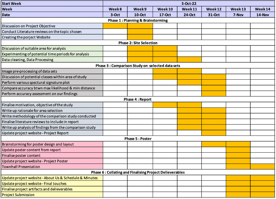
5. Project Schedule
This is our project Gantt Chart, more details on Task Allocation can be found in 6.0 Task allocation.
6. Miscellaneous
6.0 Task allocation
| Task | In-Charge |
|---|---|
| Task 1: Selection of study area | Avigale, Jia Yiing, Yuyang |
| Task 2: Data Collection | Jia Yiing, Yuyang |
| Task 3: Supervised Classification | Avigale, Jia Yiing, Yuyang |
| Task 4: Poster Design | Avigale, Jia Yiing |
| Task 5: Website Maintenance | Yuyang, Jia Yiing |
6.1 Meeting Minutes
Date Commenced : Wednesday 12 October 2022
Attendees : Ranullo Avigale, Goh Jia Yiing, Sun Yuyang
Agenda:
Discuss the individual novel research conducted for their sub-theme of interest.
Discuss and compare the various sub-theme to work on for this project.
Decide on the motivation and potential area of study
Update Gantt chart
Allocate tasks for the data collection procedures
Notes:
The meeting started with every member consolidating notes from the consultation with prof that ended earlier.
Then every member sharing about the literature studies that they have conducted with regards to each sub-theme.
Avigale: Shared about an article on Theme 2: Sub-theme 2 and the article was about the catchment area analysis of an urban railway station in Seoul. She explained how the analysis created help people to better understand the livability of residents within the area and how residents nearby could potentially benefit from it.
Jia Yiing: Shared about an article on Theme 2: Sub-theme 1 and the article was about why schools had to opt for mergers and what are the potential impacts. Relating back to what we have learnt in class, she quickly suggested that the merger and closure of schools may result in inequity of access for some students
Yuyang: Shared about an article on Theme 1 : Sub-theme 1 and felt that the topic would be relatively easier to do as the article had clear methodology on land classification studies.
After intense discussion, we do agree with the fact that the opening of Thomson-line has limited literature studies that we can refer to and hence it might be more difficult to embark on that as compared the rest of the sub-themes.
With that, we all agreed on focusing on Theme 1 : Sub-theme 1 and decided to save Theme 2: Sub-theme 1 as a back-up plan because we felt that we had a better understanding of what to do.
The team then took a bit of time to explore the relevant data and discuss on the area of study.
Avigale felt that Philippines would be easier to do as there is large areas of forested land.
Yuyang thought Shanghai would be easier to do because there is a more rapid land usage change observed in the recent years.
However, Jia Yiing quickly pointed out we are doing land cover classification and not land use. Philippines is interesting to do but we might be unfamiliar with the area to judge the classes for classification.
We then quickly come to a consensus that maybe we should explore Singapore instead since we are more familiar with the area.
Yuyang felt that she was more interested to do the west side of Singapore since she is staying nearer to the West.
Jia Yiing pointed that maybe we can explore the data images and look out for the possible areas to explore and we should avoid areas covered by clouds like West.
Avigale suggested that we can look at the north part of Singapore since there are more potential classes to explore.
With that, we all agreed to focus on the North Part of Singapore in this project. We then updated the Gantt chart and split up to finish off the data collection process within the week.